Geocoding

Understanding Geocoding: Turning Locations into Coordinates.

Geocoding is the process of converting addresses, and or place names into points on a map. Using Esri software like ArcGIS Pro, you can take a list of addresses (e.g., customer locations or store sites) and easily pinpoint them on a map as precise coordinates. This makes it simple to visualise where things are, analyse patterns, see context and relationships and make informed decisions based on location. Whether you’re mapping delivery routes, finding the closest services, or studying market trends, geocoding helps transform raw data into actionable insights.

Why Geocode?

Geocoding transforms human readable location data ( address) into actionable insights by converting addresses or place names into precise map points. This enables organisations to visualise and analyse spatial relationships, optimise operations, and make informed decisions. With tools like Esri’s ArcGIS software suite, geocoding enhances efficiency by streamlining processes such as route planning, service delivery, and market analysis. It empowers businesses to uncover trends, improve customer engagement, and gain a competitive edge through accurate, location-based intelligence.

Address to Map Conversion

Transforms addresses, coordinates, or place names into precise map points for easy visualisation and analysis.
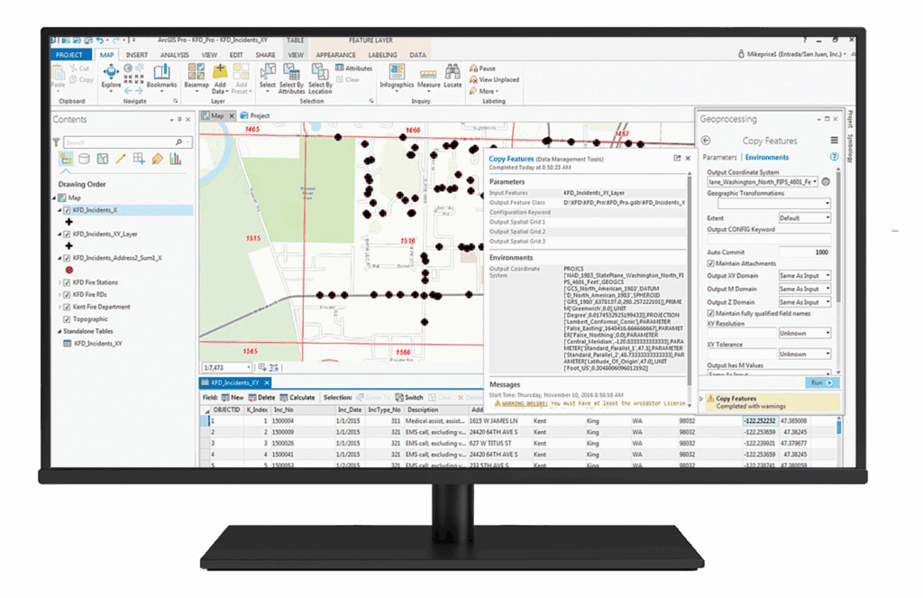
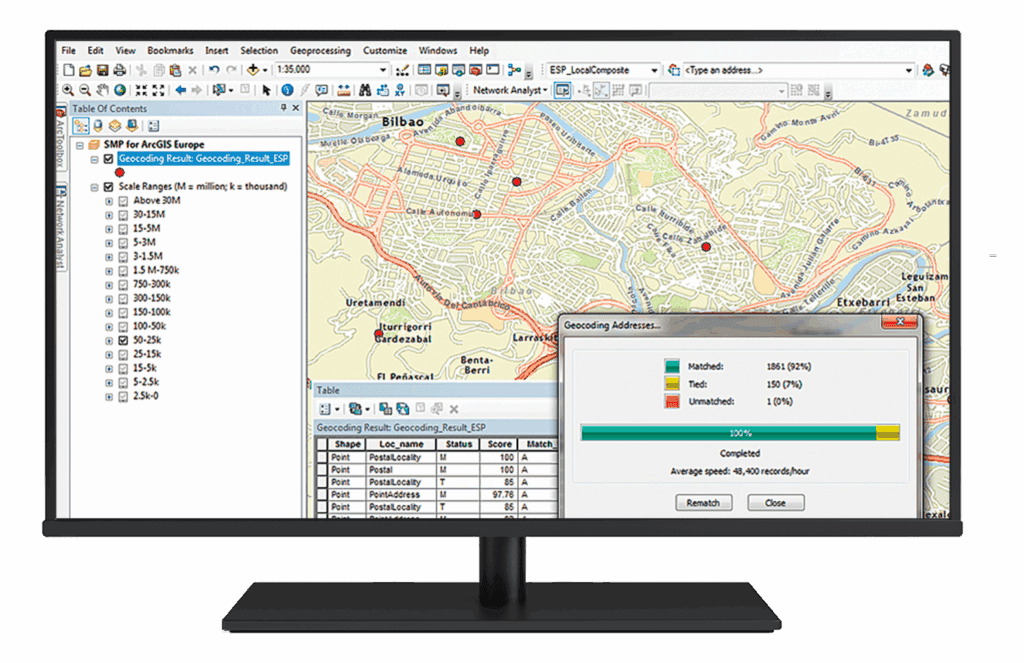
Batch Geocoding

Processes large datasets, enabling organisations to geocode thousands of locations quickly and efficiently.
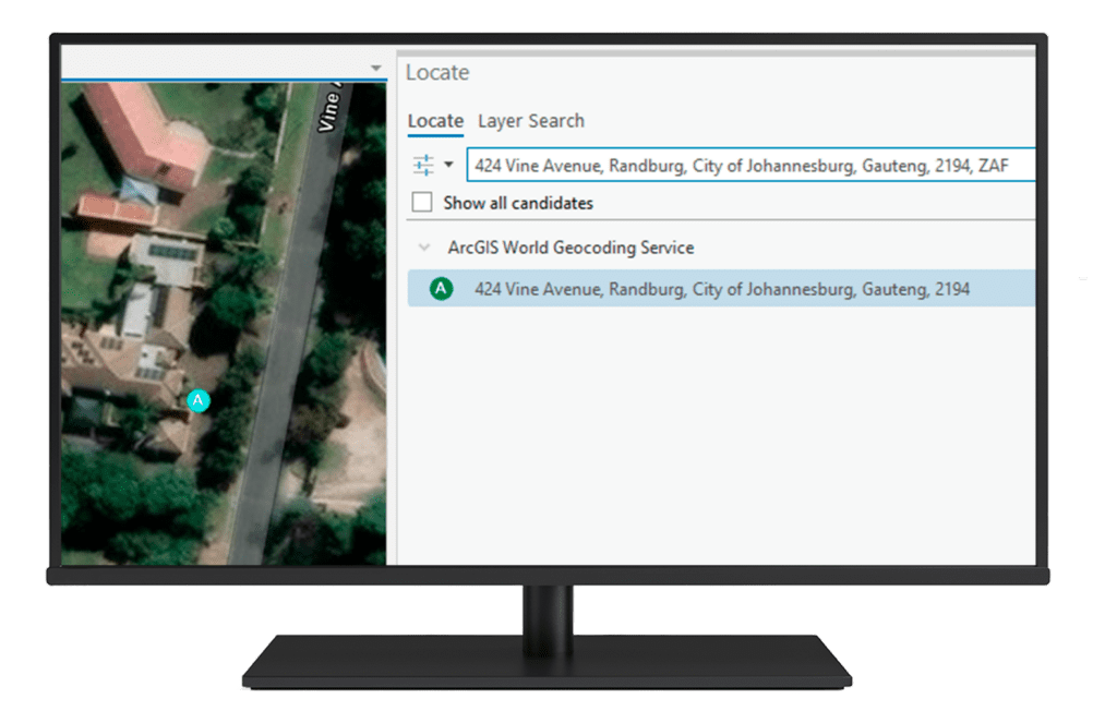
Reverse Geocoding

Converts geographic coordinates into readable address information, useful for identifying locations from GPS data.

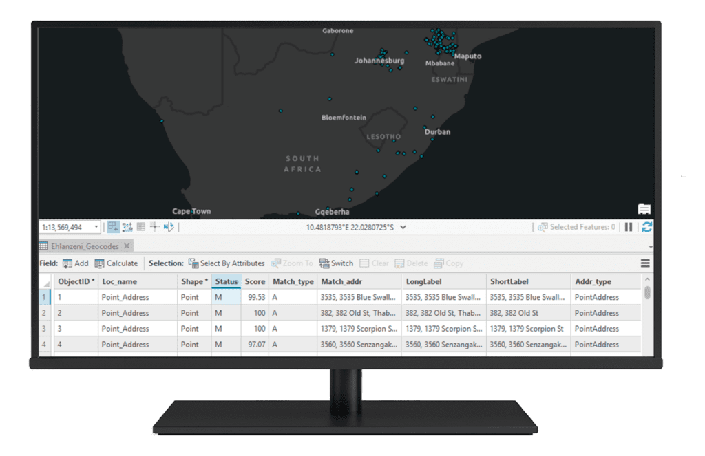
Location Validation and Accuracy

Ensures data accuracy by validating and standardising addresses against authoritative address databases.

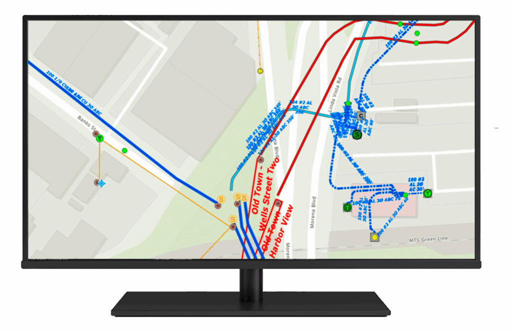
Spatial Analysis and Visualisation

 Enables trend analysis and pattern recognition by visualising geocoded data on interactive maps.
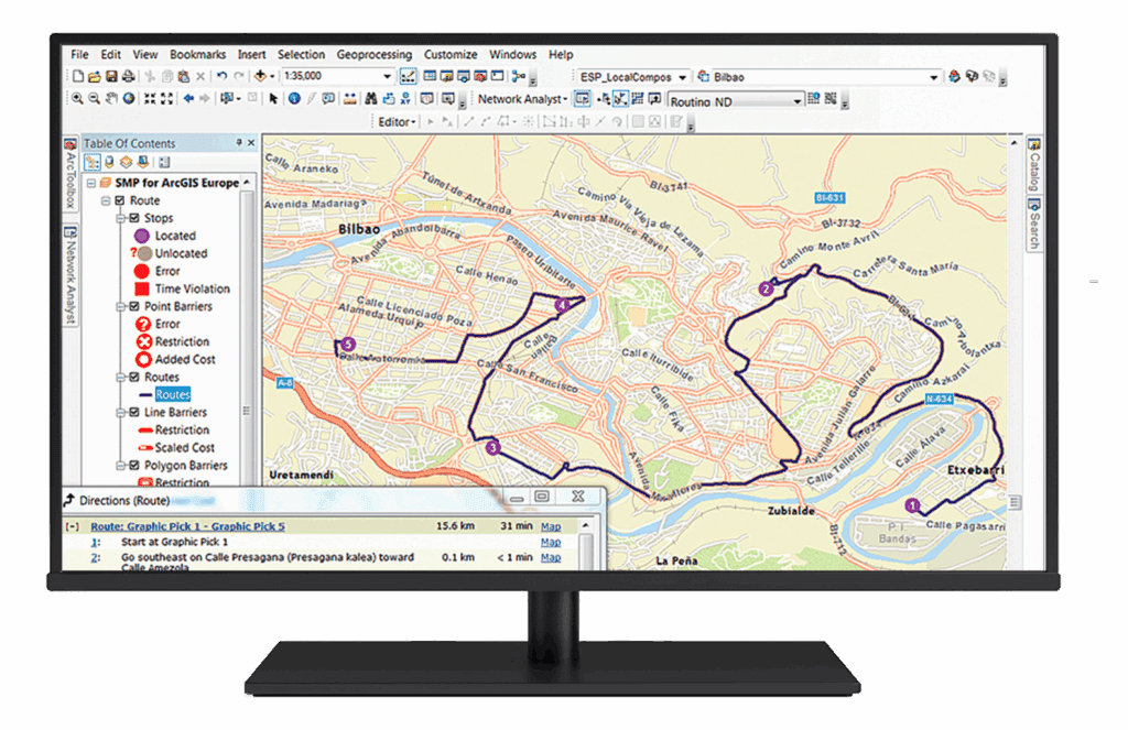
Route Optimisation

Integrates with routing tools to streamline logistics, deliveries, and service calls by identifying optimal paths.

Customer and Market Insights

Helps businesses analyse customer distributions, market opportunities, and gaps in service coverage.

Emergency and Risk Management

Supports disaster response and risk analysis by accurately locating incidents and assets.

Geocoding as a solution

A complete geocoding solution efficiently converts address data into geographic coordinates, enabling businesses to visualize and analyse locations on maps. Using tools like Esri’s ArcGIS software, the process involves data collection, geocoding, quality control, and integration with GIS platforms for advanced analysis.

This solution supports batch geocoding, reverse geocoding, proximity analysis, and route optimisation, providing valuable insights for decision-making. It enhances operational efficiency by visualising spatial relationships, optimising logistics, and improving customer targeting, all while enabling collaboration to ensure data accuracy and relevance.

Data Collection & PreparationGeocoding ProcessQuality Control & ValidationIntegration with GISApplications & AnalysisCollaboration & SharingOngoing Management & Updates

Data Collection & Preparation

• Gather address data, coordinates, or place names from various sources such as spreadsheets, CRM systems, or IoT devices.
• Clean and standardise data to ensure accurate geocoding results.

Geocoding Process

• Use Esri locator tools like ArcGIS Online or ArcGIS Pro to convert address data into geographic coordinates or map points.
• Conduct batch geocoding for large datasets and reverse geocoding to extract address details from coordinates.

Quality Control & Validation

• Validate geocoded results using authoritative address locators and databases to ensure accuracy and completeness of each address ( number, street name, suburb, town, postal code, province) .
• Adjust parameters to handle incomplete or ambiguous addresses.

Integration with GIS

• Import geocoded data into GIS platforms for further analysis, visualisation, and mapping.
• Combine geocoded points with other spatial data such as demographics, movement data, and peril data to reveal patterns, relationships, and insights.

Applications & Analysis

• Use geocoded data for proximity analysis, route optimization, customer segmentation, and risk assessment.
• Visualise results through interactive maps, heatmaps, and dashboards.

Collaboration & Sharing

• Share geocoded datasets and maps with stakeholders through web-based GIS tools or mobile applications.
• Enable collaboration by allowing users to interact with geocoded data and contribute updates.

Ongoing Management & Updates

• Regularly update geocoded datasets to reflect changes in addresses, customer locations, or infrastructure.

Site Selection as a tool for decision making

A complete geocoding solution efficiently converts address data into geographic coordinates, enabling businesses to visualise and analyse locations on maps. Using tools like Esri’s ArcGIS software, the process involves data collection, geocoding, quality control, and integration with GIS platforms for advanced analysis.

Data Collection & PreparationGeocoding ProcessQuality Control & ValidationIntegration with GISApplications & AnalysisCollaboration & SharingOngoing Management & Updates

Data Collection & Preparation

• Gather address data, coordinates, or place names from various sources such as spreadsheets, CRM systems, or IoT devices.
• Clean and standardise data to ensure accurate geocoding results.

Geocoding Process

• Use Esri locator tools like ArcGIS Online or ArcGIS Pro to convert address data into geographic coordinates or map points.
• Conduct batch geocoding for large datasets and reverse geocoding to extract address details from coordinates.

Quality Control & Validation

• Validate geocoded results using authoritative address locators and databases to ensure accuracy and completeness of each address ( number, street name, suburb, town, postal code, province) .
• Adjust parameters to handle incomplete or ambiguous addresses.

Integration with GIS

• Import geocoded data into GIS platforms for further analysis, visualisation, and mapping.
• Combine geocoded points with other spatial data such as demographics, movement data, and peril data to reveal patterns, relationships, and insights.

Applications & Analysis

• Use geocoded data for proximity analysis, route optimisation, customer segmentation, and risk assessment.
• Visualise results through interactive maps, heatmaps, and dashboards.

Collaboration & Sharing

• Share geocoded datasets and maps with stakeholders through web-based GIS tools or mobile applications.
• Enable collaboration by allowing users to interact with geocoded data and contribute updates.

Ongoing Management & Updates

• Regularly update geocoded datasets to reflect changes in addresses, customer locations, or infrastructure.

Related Content

Contact Us


Contact

Give Us a Call

+27 11 238 6300

Email

General Enquiries

[email protected]

Technical Support

[email protected]

Scroll to Top