Tailings Management Solution for ArcGIS

An integrated digital twin for assessing, monitoring, alerting, preparing, responding and reporting on your tailings facilities aligned with the Global Industry Standard on Tailings Management (GISTM®).

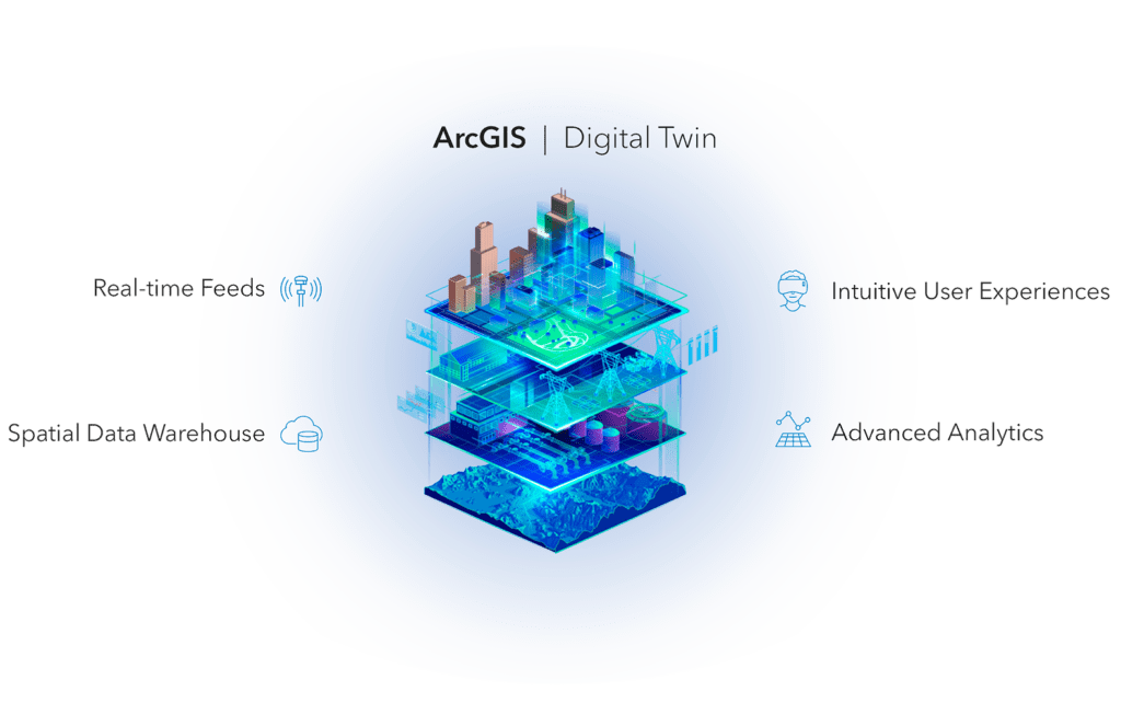
Our industry-aligned solution rapidly drives achievement of your organisational ESG goals including managing environment and social risk, mining responsibly and gaining public trust, while complying to internal and external regulatory requirements. Pick and choose from our system modules to meet your immediate and future needs across planning, construction, operations and closure. As a foundation, the solution provides an Integrated Knowledge Base that combines relevant site characterisation data with topographical data and modelled data from within the solution into a single data warehouse that is readily available for use in visualisation and analytics apps. Built on this data warehouse and the ArcGIS technology stack, modules are available for real-time tailings monitoring, emergency planning and response and public engagement.

The Value of spatially managing your tailings facilities.

As a responsible miner, you need the tools to better integrate data, understand and manage tailings-related risk, and prepare for various eventualities while ensuring compliance and engagement with external stakeholders.

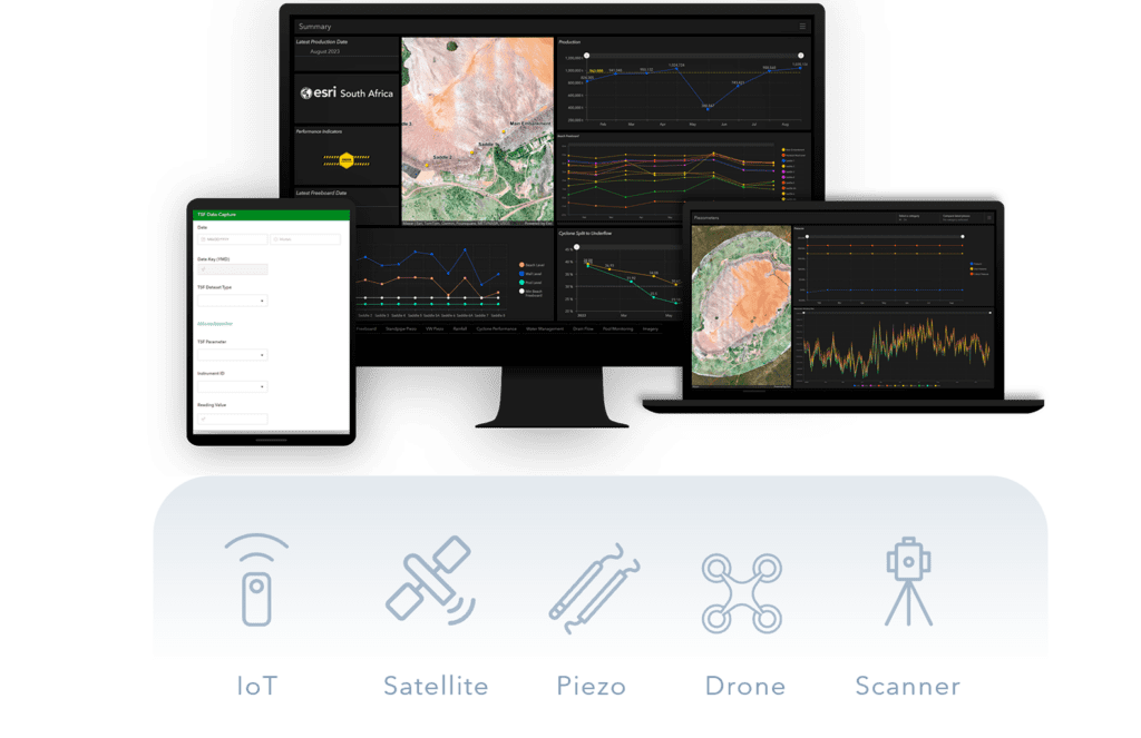
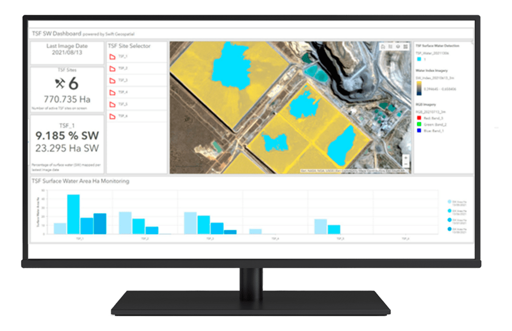
Achieve these objectives with our modern digital twin technology that seamlessly integrates real-time IoT sensors along with manual data capture and expert reports into a single platform for managing tailings facilities over their lifetime. View this data in its geographical context with maps and location data from the mine and external stakeholders to provide a comprehensive site characterisation needed to support decision making.

The solution combines robust enterprise-grade spatial data management technology, with advanced analytics and high fidelity visualisation through modern dashboards and apps to empower engineers and technicians with the right information they need at the right time. Use advanced process automation to instantly alert when thresholds are breached, and customise predictive algorithms to determine areas of risk that can be mitigated before disaster strikes.

Compliance to GISTM® guidelines
Help achieve organisational ESG goals
Leverage cutting edge digital twin technology
Gain operational efficiency
Ensure data integrity and quality
Scale with your business needs
Provide seamless access to data and insights
Build trust with internal and external stakeholders

Solution Modules

Get started using our solution with just the modules you need now. This approach allows you to grow and mould the solution to your unique organisational needs.

Integrated Knowledge BaseTailings Monitoring SystemEmergency Response SystemPublic Engagement SystemOptional Add-ons
integrated knowledge base

Integrated Knowledge Base

A data warehouse built by integrating existing data from the mine with externally provided geographic data to characterise the site and provide context through spatial awareness. This includes mining operations data as well as topographical data such as elevation model, hydrography, soils, geology, climate, flood risk as well as modelled data for flood impact zones, breach analysis, failure scenarios, as well as those created in other technical modelling packages.

tailings monitoring system

Tailings Monitoring System

Integrate site-specific monitoring system data including piezometers, vibrating wire piezometers, synthetic aperture radar, laser scanning, traditional survey data and satellite-derived data such as pond extent into a single view. Data processes are automated to ensure data integrity and provide real-time updates needed to make critical business decisions.

Combining the monitoring data with the knowledge base data warehouse, enables decision makers to easily view real-time and trend data from a single, intuitive dashboard – while threshold-based automated alerting allows an eyes-off approach for critical emergency response and risk intervention.

emergency response system

Emergency Response System

Optimise emergency preparedness through identification of vulnerable areas (people or assets) and developing appropriate interventions including signage, communication and more.

Ensure operational teams are prepared in the event of emergency by providing immediate access to critical situational awareness apps on desktop or mobile with access to the latest data, simulated or modelled data (such as breach flow model), information regarding at-risk communities and assets, ability to navigate in the field and to coordinate and monitor response teams from the control room.

public engagement system

Public Engagement System

Easily disclose critical information to the public regarding tailings status, potential impact areas, evacuation plans and more through an easy to share web link or printed posters containing critical information. Allow two-way communication with community members to ensure that all parties are transparently aware of changes to the environment and risk parameters – while recording all interactions int the archive to support auditing and reporting requirements.

optional add-ons

Optional Add-ons for Satellite-derived Insights

Our solution supports seamless integration of satellite based monitoring that automatically calculates various useful indices such as normalised difference water index (to determine surface water saturation), pond delineation, change detection as well as InSAR-based insights into long-term changes.

Solution Modules

Get started using our solution with just the modules you need now. This approach allows you to grow and mould the solution to your unique organisational needs.

Integrated Knowledge BaseTailings Monitoring SystemEmergency Response SystemPublic Engagement SystemOptional Add-ons
integrated knowledge base

Integrated Knowledge Base

A data warehouse built by integrating existing data from the mine with externally provided geographic data to characterise the site and provide context through spatial awareness. This includes mining operations data as well as topographical data such as elevation model, hydrography, soils, geology, climate, flood risk as well as modelled data for flood impact zones, breach analysis, failure scenarios, as well as those created in other technical modelling packages.

tailings monitoring system

Tailings Monitoring System

Integrate site-specific monitoring system data including piezometers, vibrating wire piezometers, synthetic aperture radar, laser scanning, traditional survey data and satellite-derived data such as pond extent into a single view. Data processes are automated to ensure data integrity and provide real-time updates needed to make critical business decisions.

Combining the monitoring data with the knowledge base data warehouse, enables decision makers to easily view real-time and trend data from a single, intuitive dashboard – while threshold-based automated alerting allows an eyes-off approach for critical emergency response and risk intervention.

Emergency Response System

Optimise emergency preparedness through identification of vulnerable areas (people or assets) and developing appropriate interventions including signage, communication and more.

Ensure operational teams are prepared in the event of emergency by providing immediate access to critical situational awareness apps on desktop or mobile with access to the latest data, simulated or modelled data (such as breach flow model), information regarding at-risk communities and assets, ability to navigate in the field and to coordinate and monitor response teams from the control room.

Public Engagement System

Easily disclose critical information to the public regarding tailings status, potential impact areas, evacuation plans and more through an easy to share web link or printed posters containing critical information. Allow two-way communication with community members to ensure that all parties are transparently aware of changes to the environment and risk parameters – while recording all interactions int the archive to support auditing and reporting requirements.

Optional Add-ons for Satellite-derived Insights

Our solution supports seamless integration of satellite based monitoring that automatically calculates various useful indices such as normalised difference water index (to determine surface water saturation), pond delineation, change detection as well as InSAR-based insights into long-term changes.

Related Content

Contact Us


Contact

Give Us a Call

+27 11 238 6300

Email

General Enquiries

[email protected]

Technical Support

[email protected]

Scroll to Top