
Comparing the capabilities of Esri’s graphic visualization tools
First things first, what are we comparing? Esri has two dashboard tools -namely Web AppBuilder and Operations Dashboard-, and one business intelligence (BI) tool -namely Insights. Before we delve...
New Year, New User Types!
The latest version of ArcGIS Online comes with major changes. The most prominent one being the latest update to the named user licensing model. A new and very flexible way to license...
Integrating with business systems – where to start
Esri’s goal with the WebGIS (see this blog on “What is Web GIS”)concept is to break down silos and make spatial data and processing services accessible to anyone that wishes to use them. This...
Mining User Group members share experiences of ArcGIS roll-outs
Hear from industry peers on how they have achieved success in rolling out ArcGIS.

How to install the ArcGIS API on ArcGIS Pro Python (offline)
Esri has fully embraced Python for ArcGIS and sees Python as the language that fulfills the needs of the user community. Previous versions of ArcGIS Desktop...

FIFA World Cup 2018 Stadium Guide – Russia
The background story… The motivation to create this story map series application is sourced from my true love for soccer (or as some like to call it, ‘football’). I have always watched and loved...
Using Python to aggregate values in related tables for mapping purposes
Very often important information is stored in related tables in a geodatabase. What happens if you want to symbolise a map using this data, or if you want to use this data as input into analysis...
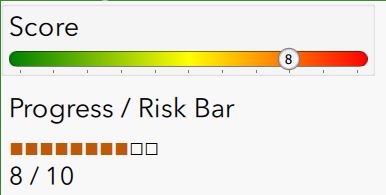
Survey123 – Progress / Increment bar
Let's kick the year off with something special - A customized progress / increment bar for Survey123! For a recent survey that I designed I wanted to give the user visible feedback of a risk factor...
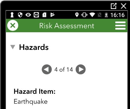
Survey123 with a single attribute for repeating generic questions (instead of multiple attributes); and an auto-incremented list!
Example Requirement: You are being tasked with creating a Disaster Risk Assessment form (as above) which requires the field worker to capture the risk factor associated with 14 Hazard Items:...