Improving underground mine safety
Pillar safety analysis on the map: Thinking about Lily Mine as reported by Mail & Guardian on February 15,2016, that the central pillar of ore, called a crown pillar, collapsed subsequently...
Monitor your assets in real time
As part of the ArcGIS Platform, the GeoEvent Extension for Server enables real time data processing and works seamlessly with your other ArcGIS software. Several of our clients have a need to...
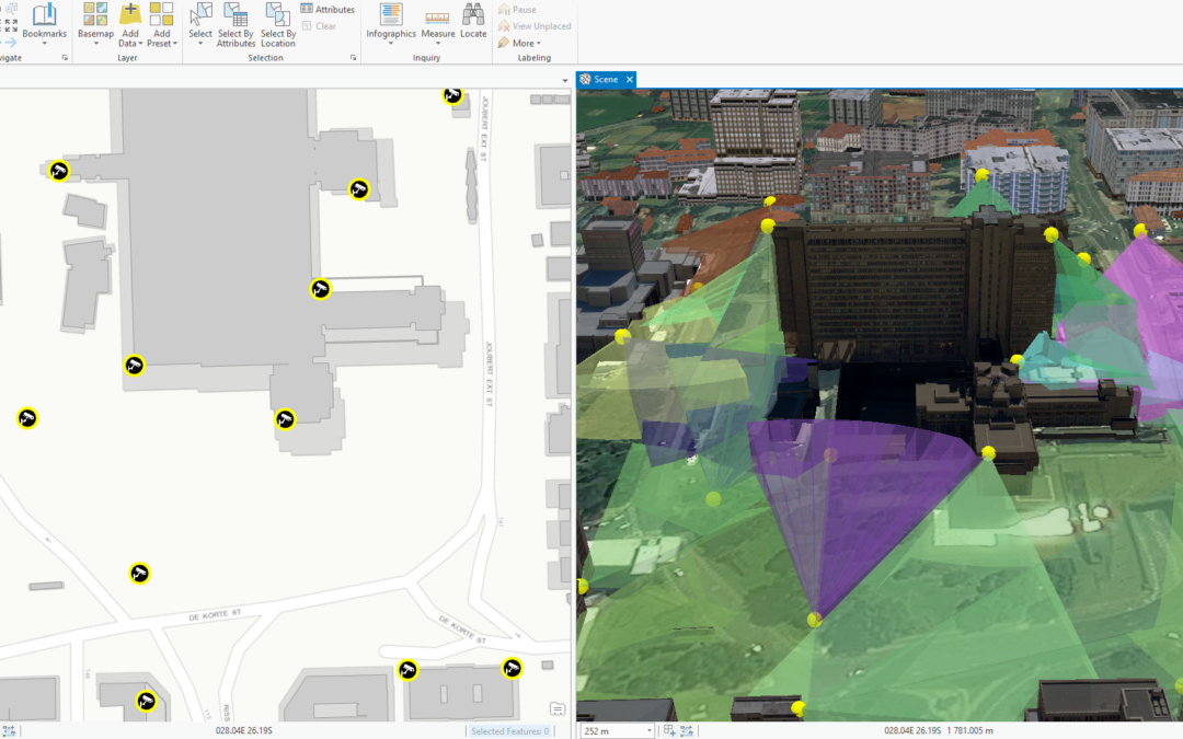
CityEngine & ArcGIS Pro combine to show CCTV coverage in 3D
As part of our Modelling Reality in 3D series, this post looks at the Esri Africa User Conference demonstration of CCTV camera placement in 3D. A prominent United Nations study notes that the share...
Determining Solar Potential for Rooftops of Multipatch Feature Types
Part of the Modelling Reality in 3D series Often times there are problems that simply have to be solved in 3 dimensions in order to attain the appropriate results. This doesn’t have to be scary...
ArcGIS Earth is here!
Version 1 of ArcGIS Earth was officially released mid-January 2016. The application offers functionality to share data in a similar way that Google Earth does. For Esri customers ArcGIS Earth offers...
Modelling Reality in 3D with ArcGIS – Blog Series
Welcome to 2016! This is going to be a bumper year on the Esri South Africa blog so be sure to keep checking back for new content (or you can subscribe using by clicking the FOLLOW US button on the...
Migrating Python Scripts to ArcGIS Pro
What’s new? With the migration towards 64-bit processing in ArcGIS Pro, some big changes have come to the Python environment as well. Python in ArcGIS Pro has been upgraded to version 3.4. All other...
ArcGIS Open Data
The need to share GIS data with the public or internally in an organisation has grown markedly over the past years. Until recently, sharing data was often a manual, tedious task. Governments in...
Esri AUC 2015 – the highlights package!
The very first Esri Africa User Conference has shut its doors. And what an incredible experience it was for us all! It’s not every day in Africa that you can walk around with over 900 people that...